Instruction
Very well done! Since you already know how to tackle hierarchical structures represented in the form of trees, it's time to move on and introduce the second type of real-world situations we can tackle with recursive CTEs: graphs.
Graphs consists of vertices and edges. In real life graphs can often correspond to road maps. Take a look:
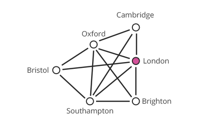
In a database, we may store vertices (cities) in one table, and the edges (roads between them) in another one:
| city |
|---|
| name |
| London |
| Cambridge |
| ... |
| road | ||
|---|---|---|
| name_from | name_to | distance_km |
| London | Cambridge | 78 |
| ... | ... | ... |
For educational purposes, we will simplify things a bit. We will only use a single table city with the city name and gps coordinates and we assume that you can go directly from each city to another.
First, let's take a look at this table.
Exercise
Select all data from table city.
The table contains the following columns:
name– name of the city.lat– latitude of the city.lon– longitude of the city
Last two columns indicates coordinates. Based on those coordinates, we will calculate the distance between two cities in a straight line and treat it as the distance.